German satellite aims to support climate protection
Environmental mission EnMAP: Fraunhofer IOF contributed mirrors for the first German hyperspectral satellite
Recently, the first hyperspectral satellite developed and built in Germany was launched into space. Its name: EnMAP. In the future, it will analyze Earth’s environment from space, making visible not only the consequences of climate change but also potential natural hazards. A total of eleven mirrors and various optical layers for telescope and spectrometer optics were manufactured for this mission at the Fraunhofer Institute for Applied Optics and Precision Engineering IOF in Jena. One month after the launch, the first images from space are now available.
It is one of the most important questions of our time: How can we improve the protection of our environment and our climate? A new satellite mission of the German Aerospace Center (DLR) aims to provide answers: The “Environmental Mapping and Analysis Program” - EnMAP for short - is the first German hyperspectral satellite. The EnMAP mission is being managed by the German Space Agency at the German Aerospace Center (Deutsches Zentrum für Luft- und Raumfahrt; DLR) in Bonn on behalf of the Federal Ministry for Economic Affairs and Climate Action (Bundesministerium für Wirtschaft und Klimaschutz; BMWK).
Its goal is to provide excellent images combined with spectral data to gather diagnostic information about the state of our Earth and waters. It can also be used to look at the effects of human intervention on ecosystems and to help manage natural resources, such as agriculture.
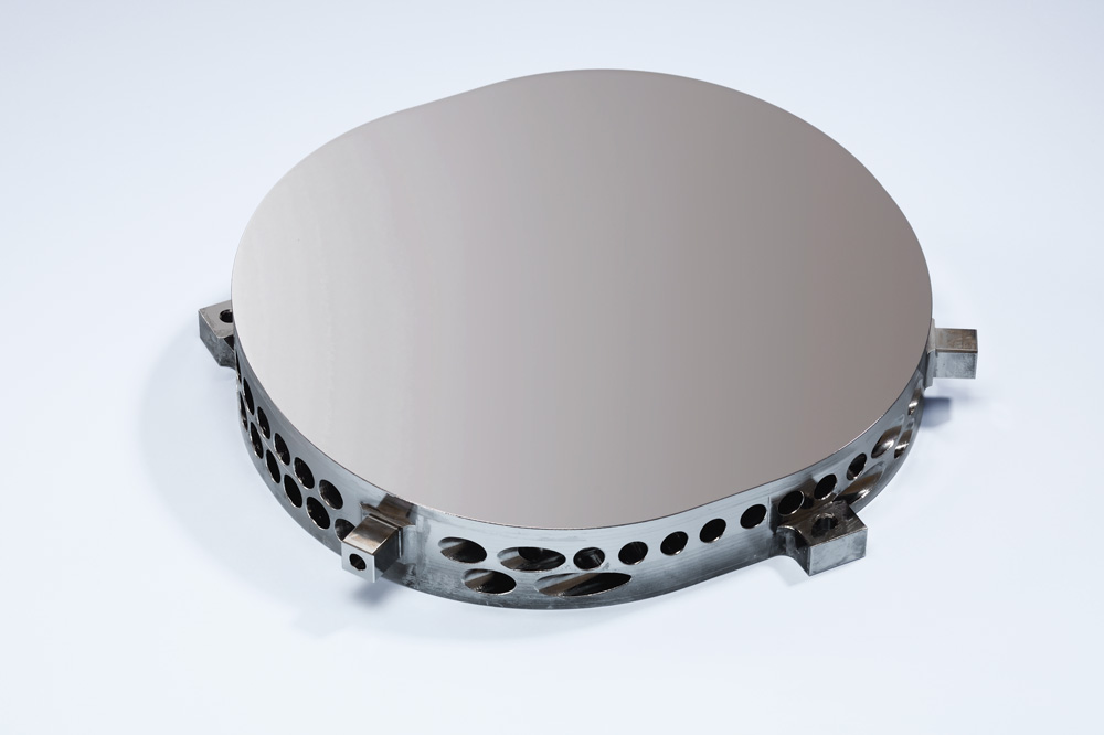
On April 1, the EnMAP satellite was successfully launched into space from Cape Canaveral Space Force Station in Florida on a SpaceX Falcon 9 rocket. On board: metal mirrors, manufactured and optically coated at Fraunhofer IOF in Jena.
Fraunhofer IOF contributed metal mirrors for EnMAP measuring instrument
Over the next five years, the satellite will observe our Earth from a distance of about 650 kilometers - on 242 spectral channels. Its central measuring instrument is the so-called Hyperspectral Imager (HSI). It is capable of measuring the solar radiation reflected from the Earth's surface as a continuous spectrum in the spectral range from 420 nm to 2,450 nm, with a spectral sampling of 6.5 nm (VNIR) and 10 nm (SWIR). At the same time, the imaging spectrometer provides brilliant images with a spatial resolution of 30 m x 30 m on Earth.
“For the HSI, we developed a total of eleven plane, spherical and aspherical metal mirrors at Fraunhofer IOF. The development covered the mirror design, the manufacturing, and the coating of the mirrors as well as the characterization with optical and tactile measurement methods,” explains Dr. Stefan Risse, head of the project at Fraunhofer IOF.
The mirrors are used in the visual and infrared spectral range. They were therefore manufactured by combining ultra-precise diamond machining processes with polishing techniques for local shape correction and smoothing of the surface roughness. The optical surfaces were finished with coating layers of protected silver for the visual spectral range and sputtered gold for the infrared spectral range.
“Metal mirrors made of an aluminum alloy combined with an X-ray amorphous thick film of nickel-phosphorus are used. This allowed state-of-the-art optics manufacturing processes to be applied to metal optics as well. As a result, mirrors with a microroughness of less than 0.8 nm rms and shape accuracies of less than 12 nm rms were achieved,” the researcher adds.
EnMAP sends first images from space
Hyperspectral analysis breaks light into many, closely spaced wavebands. That's also the job of the HSI on board of EnMAP: It observes sunlight reflected from materials on the Earth's surface. Since each material has its own way of reflecting light, the result is a very specific, colored spectral signature that is invisible to the human eye. There is a good reason why EnMAP claims to be able to see ‘our Earth in more than all colors’.”
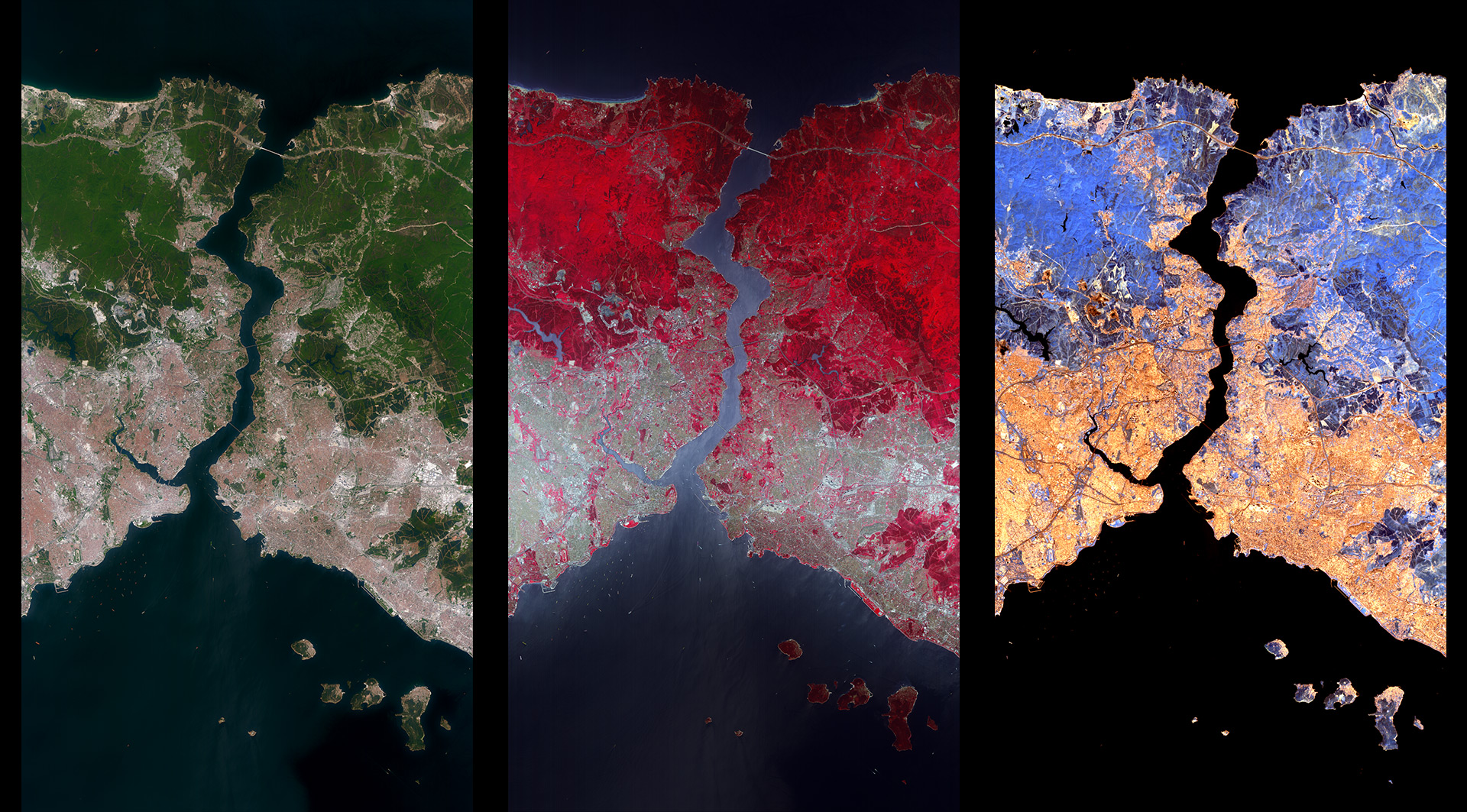
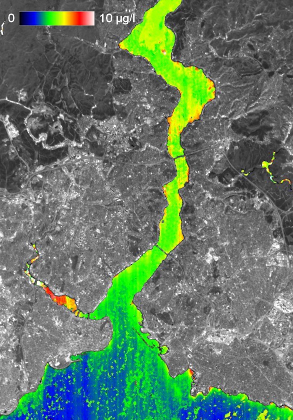
Four weeks after its launch, EnMAP has now sent home the first images from space. They show a strip about 30 kilometers wide and 180 kilometers long over Istanbul on the Bosporus in Turkey. The data were sent to Earth via the DLR ground station in Neustrelitz. In another five months, the mission is scheduled to enter the operational phase. Then scientists can start collecting data on specific areas of the Earth.
“The imaging hyperspectral instrument of the EnMAP mission was realized under the responsibility of DLR using German technology and currently constitutes a cutting-edge instrumentation in terms of its spectral width and excellent imaging quality,” explains Prof. Dr. Andreas Tünnermann, director of Fraunhofer IOF. “Ultra-precise optics from Fraunhofer IOF have played a decisive role in this. EnMAP makes an excellent contribution to preparing Germany and the world for the challenges of climate change. As Fraunhofer IOF, we are therefore very proud to be part of this pioneering mission."
Partners of the German environmental mission EnMAP
The EnMAP mission is being managed by the German Space Agency at the German Aerospace Center (Deutsches Zentrum für Luft- und Raumfahrt; DLR) in Bonn on behalf of the Federal Ministry for Economic Affairs and Climate Action (Bundesministerium für Wirtschaft und Klimaschutz; BMWK). OHB System AG was contracted to develop and build the satellite and the hyperspectral instruments. The German Research Centre for Geosciences (GeoForschungsZentrum; GFZ) in Potsdam is the science principal investigator for the mission.
Three DLR institutes and facilities have been commissioned for the construction and operation of the ground segment. The German Space Operations Center in Oberpfaffenhofen will conduct and monitor satellite operations, while the German Remote Sensing Data Center and the DLR Remote Sensing Technology Institute will archive, process, and validate the received satellite data and make them available to the scientific community. Companies and public authorities will also test the data and use them to prepare future services. The use of EnMAP hyperspectral data by universities and scientific institutions and the development of special applications will be supported by BMWK funding programs.
The mirrors were manufactured at Fraunhofer IOF on behalf of OHB System AG.
